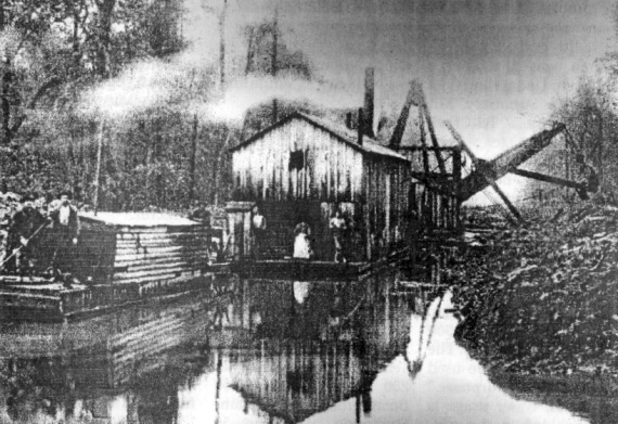
-- the photo above features the type of dredge used on the Kankakee River in the early years of 1900? A logging crew worked ahead of the dredge, cutting underbrush and trees in a 200-foot swath, as the steam-powered digger crossed the many curves of the old river, digging the "Marble Power Ditch" ten feet deep and 90 feet wide. The cut logs were piled upon the ditch banks and covered with soil or used to power the dredge. The work was finished to the Illinois state line about 1923.
-- the Old Timer ‘dug up’ an old story about a grave robbery in Lowell? According to a story in a local newspaper printed many decades ago, some ‘medical men’ hired a man to dig up the body of a recently buried local man, but when the flame from a lantern set fire to the natural gasses at the grave, the grave digger thought that the fires of hell were after him and ‘ran a furrow’ through the burial ground. The ‘medical men’ who were interested in the body for research, were arrested and punished.
-- pilot Dan Sutton reported that remnants of the old ‘plank road’ between Creston and Cedar Lake are still visible from the air? The old road, made of piling and heavy planks, was built through the swamp between Creston and Paisley, an early village at the south end of Cedar Lake.
-- the large condominiums now standing near the corner of Lake Shore Drive and 133rd Ave. in Cedar Lake are on the site of a proposed pioneer town? Before Lake County was founded in 1837, pioneer Benjamin McCarty platted the town of West Point in that area, but when Crown Point became the county seat his plans were changed. The large hill, now bulldozed, in the area was also the site of the Kennedy Hotel, and the site of the first grave of Obadiah Taylor. Bodies from that site were moved many years ago.
-- the one-room frame Buncombe Elementary School once stood at the southeast corner of Cline Ave. and Belshaw Road, the recently proposed site of the new Lowell Middle School? The old school building was destroyed by fire or by a tornado some time before 1920.
-- a picture of the "Oakland Stock Farm" shown in a 1909 history volume was listed as owned by William Coy? Can anyone tell us where this West Creek Farm was located?
-- a very picturesque panorama is yours for the viewing at the crossroads of Belshaw Road and Clark Road? Looking south from that corner you can see the Kankakee Valley, with the trees to the south near the historical river, where often a blue haze lies over the woods.
-- the proposed subdivision with a marina already under construction at Cedar Lake is along Cedar Creek? There was an early grist mill at the outlet; then the meandering stream operated another mill at what is now Lake Dalecarlia, then flowed south to Lowell where several more mills were powered by water during the pioneer days, when founder Melvin Halsted platted Lowell in 1852. The same waters powered a mill at 205th Ave., south of Lowell, near the old village of Egypt.
-- a large 1914 photo of the old Oakland School on Belshaw road east of US 41 shows all the students as well as a horse drawn school bus? The brick school was built that year, but no longer exists. The photo can be viewed at the Halsted House Museum on the northeast corner of Main and Halsted Streets. Nearby is another large photo of the second Hayden Family Reunion in 1916.
-- the first fire truck in Lowell was purchased in 1916 by the town and the township? Before that time there was a horse-drawn ladder and bucket wagon pulled by a team of spirited horses owned by the McNay Coal and Express Company and a hose cart was towed by the devoted firemen. A new driver for the express company had quite a surprise when the fire bell rang and the horses took off on their own to the fire station.
-- this notice appeared in the Lowell Tribune? -- "There will be an important meeting of the Lowell Horse Detective Association on Sat. October 15 [1904[ at the Opera House. There should be an awakening of this very useful organization."
-- the "Lowell Seniors" played a baseball game with the famous "Bloomer Girl" team in 1904? The game was a financial success, and the men beat the girls 16 to 5 as the M. C. Wiley Brass Band played.
-- there was an Indian Peace Treaty signed at Lowell during the pioneer days? The "Pine Tree Treaty " took place near what is now West Commercial Avenue and was signed by the pioneers and the Indians after a pipe of peace was smoked by all concerned, ending the looting and returning peace to the village.
-- the elevation in the area of the Town of Lowell is about 665 feet? At the Town of Schnieder, near the Kankakee River, the elevation is a bit lower, near 636 feet.
-- the Lake County Alms House ("Poor Farm"), a frame building, was built for the poor in 1884? It stood on 310 acres of farm land two miles east of the City of Crown Point and was replaced in 1912 by a larger brick building capable of housing 350 persons. It no longer exists.
-- during a heavy rain storm (1873), accompanied by a bad gale of wind, fences blew down and opened fields to the live stock? A large volume of water rushed through the broken dam at the McCarty grist mill (Lake Dalecarlia), undermining the Sigler-Heiderman mill to the south. The dam at the Sigler mill gave way and the building was nearly washed away. The flood waters rushed on to Lowell, where the "waste water" ditches saved the Halsted Mill.
-- a lot of Lowell’s History can be viewed at the Halsted House Museum? Open every first Saturday from 11 am to 3 pm or for private tours by groups or individuals. Call 696-9234, 696-9336 or 696-0641. Northeast corner of Main and Halsted Streets in Lowell.
-- the museum would be happy to accept donations of sewing forms for display of period garb and uniforms?
Return to Lowell History
Return to the "Pioneer History" A to Z Index Page
Contact referenc@lowellpl.lib.in.us